London Air Ambulance Service
12 July 2021The London Air Ambulance Service (LAAS) is a busy unit. No more evidence is needed than the amount of time taken to gather the background for this article - several phone calls were interrupted by a 'shout' and a 'sorry, gotta go!' from one of the LAAS aircrew. They also have a highly complex, fluid and demanding 'patch'. London is just different to other conurbations. It's sheer scale and size demand a different approach and mindset. Compared to Greater Manchester, Greater London has a larger population by nearly 7 million. The city has dozens of museums, sports stadia and event venues all attracting (in normal non-Pandemic times) tens of millions of tourists and visitors annually. From an Air Ambulance perspective, Greater London has dozens of hospitals, many with Accident and Emergency Units, and five large civil airports, including two (London Heathrow and London City) that have approach and departure paths over large sections of London's central and suburban areas. There is also military, and increasingly civil, traffic in/out of RAF Northolt and there are several burgeoning General Aviation airfields to consider, some of which, such as Biggin Hill, also have instrument procedures that see aircraft operating over the extended suburbs of the UK's metropolis.
The complexity of the airspace in and around London is further complicated by a number of permanent and temporary airspace restrictions (such as 'The Specified Area' over The City) to protect sensitive buildings and the frequent events that London attracts - and Air Traffic Control closely monitor the flightpaths of all aircraft operating in the Capital's skies. They are, understandably, wary of lost or incorrectly height separated helicopters triggering either a TCAS alert and (expensive, not to mention embarrassing) 'go around' of an airliner at Heathrow or City airports and, particularly post the September 11 attacks, on the watch for aircraft with more nefarious motives. Nobody is immune from the 'wrath' of Heathrow or Thames Radar; rumours abound of a pair of USMC MV-22 Ospreys being unceremoniously ejected from the Heli Lanes in 2006 after completing a photo-op sortie as they were consistently unable to keep to the tight routing and height restrictions in place over the West side of London - restrictions necessary to keep airliners descending into Heathrow safe.
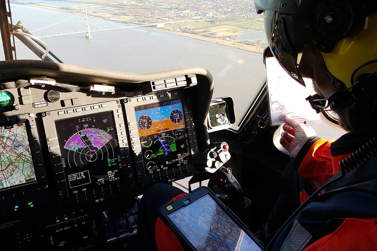
As explained by LAAS pilots Dave Rolfe and Andy Thomson, this complex and congested operating environment was one of the key factors in selecting the Airbox ACANS system to give crews enhanced Situational Awareness (SA) and improved navigation capability. "We still fly the MD902 Explorer" noted Dave, “It is a lovely machine - perfect for the HEMS role". Clearly enthusiastic about the aircraft, he praised the cockpit visibility, performance (provided it didn't get too hot...) and continued by saying that the compact dimensions and NOTAR (NO TAil Rotor) configuration made it ideal for operations in and out of small roof top heli-decks and the parks, gardens and street junctions that often prove to be their ad hoc emergency Helicopter Landing Sites when 'on the job'. For those unfamiliar with NOTAR technology, in simplified form, as opposed to a conventional helicopter (eg Bell 429) with a tail rotor, or a shrouded Fenestron (used on the Airbus H135), in the MD902 yaw stability is provided by the acceleration of engine exhaust efflux over the tail boom - exploiting the 'coanda effect'- and a rotatable 'bucket' controlled by the yaw pedals is mounted at the end of the tail boom which vents exhaust gas directionally to permit yaw control.
What was not so nice, however, about the MD902 was the increasingly archaic and obsolete moving map system. "It was old, increasingly unsupportable and had not been updated for years" Dave recalls. This required the crews to 'work around' the map system rather than derive benefit from it. For example, Andy recalls that using the legacy system they had to enter a location into an Excel program to generate a heading/Range to the nearest hospital. This added time and the risk of human error into the process - and, in an emergency, neither are welcome factors.
Worse, as Andy recalled, on some occasions the crews actually got lost using the old kit. He referenced a sortie in the Windsor area, slightly outside their normal 'patch', where the crew lifted and transitioned 90 degrees off planned heading. There was no clear moving map display that could immediately provide a 'gross error check'. The crews began to realise that 'enough was enough' and requested a new Moving Map System be provided. The Charity agreed with the crews, and the Unit started the process of looking for an applique system that could be used in the MD902s without incurring unaffordable integration and modification costs into the cockpit, or the adoption of a 'fuller' Supplementary Type Certificate (STC) navigation upgrade that was considered 'overkill' for the task at hand, as it would be entirely aviation focussed.
Some of the crews had experience of Airbox products from the General Aviation scene, and they contacted the company to see if they could help deliver a new Moving Map System with some tailorable, non- aviation specific, overlays and interfaces. LAAS crews needed a system that was simple, intuitive, and easily updatable - and one that cut down the amount of 'mandraulic' effort they were having to use to work around their existing system. This would free up capacity for other tasks whilst en route' and, crucially, enable crews to spend more time heads-out looking for obstructions, other aircraft and, increasingly, drones.
Both Dave and Andy note that ACANS has delivered handsomely on this intent - providing far more capability than just a better and more updatable Moving Map. Both praised Airbox's ability to engage and understand with their needs. "Of course, it's got the aviation mapping we'd need - various chart scales and specialist maps - such as the London Heli Lanes - but it's got so much more, bespoke, add-ons that make our job easier" Dave enthused. To make control of assets over London easier, the Capital is divided into a grid. Many readers will be familiar with the 'London A-Z' - and ACANS can accept inputs via A-Z page number, street name 'gazetteer' or London Grid. However, less well known, is that Air Traffic Control also maintain a separate Grid system for maintaining Situational Awareness on Police, HEMS and TV units that routinely operate over the capital. This grid enables the crews to call ATC and give them rough operating areas, rather than a Post Code, Address or A to Z Grid/Page number. Before flight, as one pilot is running to start the aircraft, the co-pilot will, amongst other 'dispatch' items, speed-dial the Swanwick ATC centre and let them know where they will be operating. this information can be passed digitally to all relevant ATC agencies. Once in flight and 'on task', when moving around the city between base, incident and hospital, crews can quickly inform ATC that they are in transit from ‘top right-hand corner of square X to the bottom left hand corner of square Y' - it's all the fidelity ATC need to inform those concerned about potentially conflicting traffic. ACANS provides this overlay, along with the A to Z and other specialist Police/Emergency Services applications. The 'Search' facility is a particularly handy tool. ACANS also provides an Electronic Flight Bag (EFB) functionality to the pilots, enabling them to access Operations Manuals and Aircraft Flight Manuals in flight as well as maps, charts, and approach plates - although a true performance tool, such as Easy Weigh, is not currently included. "ACANS does, however, provide a helicopter crew management function 'Crew Members', making it easier for the crews to keep track of their Flight Time Limitations (FTLs), complete their logbook summaries, and to track data for entry into the Aircraft Technical Log post flight."
The LAAS Standard Operating Procedure for ACANS is to carry two iPads onboard. One is mounted in the cockpit and used by the Handling Pilot for navigation and the other by the Co-Pilot, who uses it to 'mission manage' the call-out, communicate via chat windows with other assets and exploit any EFB functionality when required. Originally, the crew tried to fly with just a single iPad but realised quickly that viewing angles and glare cross-cockpit made it difficult for the Handling Pilot to assimilate the necessary data.
Both pilots were full of praise for the journey that LAAS have taken with Airbox. 'Right from our first engagement with Airbox, via Tim, through to our current Customer Account Manager, Lauren, it's been more of a partnership than supplier-customer relationship' suggests Dave. ACANS as a product is in continual development, and, most importantly to LAAS, 'it has developed with our needs'. Dave went on to suggest that the response to the COVID-19 pandemic has been a real boost to the functionality and connectivity that ACANS provides - with significant benefits to flight safety as a result. He mentioned that, for the first time, thanks to several ACANS tablets being provided to the military assets (Chinooks, Pumas and Wildcats) assigned to the COVID 'Aviation Task Force' (ATF), all government and NGO aviation assets likely to be operating in/out of key sites (ATF, HEMS and NPAS) are 'visible' on ACANS. This invaluable SA tool enables crews to be aware of when pads / HLS' are occupied, and to see when other assets lift/depart, permitting crews to plan and select approach routes to avoid the chances of an Air Prox (near miss with another aircraft) or worse - particularly useful at night over urban areas where it can be hard to discern even an aircraft strobe light against a light-cluttered background. I'm sure many ex-military aviators would have been significantly helped by such an SA tool around busy facilities in Northern Ireland during 'The Troubles' - especially sites such as Bessbrook Mill (Red 850....you never forget...) which was once, by reputation, the busiest Heli Port in Europe and, sadly, scene of a tragic night-time mid-air collision between a Gazelle and Puma in 1992
Finally, our discussions turned to the future and some likely significant changes to the LAAS fleet. Dave lamented the increasing need to replace the MD902s. Much as the crews evidently like the aircraft, and appreciate its qualities for the HEMS role, there is a growing realisation that it is now an aging aircraft with an industry-acknowledged Achilles Heel in terms of spares provision and other post-design support. Indeed, it has become something of a 'norm' for spares to be sourced by stripping and parts-recovering retired airframes. Although no replacement has been selected yet, both pilots note that it's hard to look past the Airbus H135 as the other alternatives, such as AW169, have slightly larger 'footprints' which could cause issues with some of the locations that LAAS frequent.
What is in no doubt, however, is their commitment to ACANS. Indeed, the team at LAAS would like to see further functionality and connectivity added. The 'dream' is to have all Emergency Services air and ground units connected into ACANS, allowing the seamless passing of messages, data and sensor imagery between users, leading to less human error. Much of this 'connectivity' is currently 'air gapped' between systems by the 'Human In The Loop' - which is time consuming and runs the risk of data being corrupted - especially easy to do in a darkened, cramped and often vibrating helicopter cabin and cockpit. It's another factor that also prevents all crew members from looking out for hazards. Form a LAAS perspective, they would like to see the next upgrade to the Dispatching software, currently separate from ACANS, incorporated into it - removing another time and convenience hinderance. Dave noted that Airbox are already looking into this as a future update.
Another growing issue for LAAS is the ever-increasing use of Drones over London. In many ways, Drones are the new 'laser pens' in terms of a hazard to Police/HEMS crews operating over built-up areas. Like laser pens, most Drone users mean no harm, or are simply ignorant to the danger they pose. As recently as May this year, LAAS suffered a Class A Airprox (the most severe report) when a drone hovered below one of its MD902s as it was trying to land with a critically ill patient at the roof-top helipad at the Royal London Hospital in Whitechapel. The thought of a drone-strike damaging a helicopter is bad enough, but the spectre of one initiating an accident sequence that resulted in a fuel-laden helicopter crashing into a crowded London thoroughfare is enough to give pause for thought. The Drone issue is, if anything, becoming more acute with prices lowering, UAV capabilities increasing and more people spending time at home due to Covid. Some form of Drone tracking tool on ACANS would, the crews suggest, be of increasing use as the skies become ever more cluttered with them.
Finally, the crews would like to see the Performance / weight and balance capability re-introduced. The change in aircraft type in the near future appears to be the logical time to 'wrap in' such a system in negotiations.
LAAS are clearly happy with the ACANS product and have appreciated how little 'tweaks' they've requested have been dropped into the system by the team at Airbox. They remain committed ACANS users, and part of the user community striving for greater connectivity and data sharing. Crucially, they trust Airbox to take the journey with them.